For a Hurricane to develop, there are a number of elements that are required.
Heat Sources
The main sources of energy for a hurricane:
Latent heat is released as the rising water vapor condenses. The result is an increase in temperature of the surrounding atmosphere.
- Warm Ocean Surface
- Latent Heat
Latent heat is released as the rising water vapor condenses. The result is an increase in temperature of the surrounding atmosphere.
Unstable Atmosphere
An unstable atmosphere promotes vertical movement of air. As warm, ocean water evaporates, it rises due to convection and cools following the dry adiabatic lapse rate. This rising air is buoyant therefore less dense than the surrounding air. As it rises, it becomes saturated as it cools to its dew point temperature. At the lifting condensation level (LCL), moisture in the rising air will begin to condense or change from the vapor phase to the liquid phase and clouds will form. This phase change releases energy in the form of latent heat. Numerous thunderstorms can develop from this convection and the area containing these storms is known as a tropical disturbance.
Easterly Waves
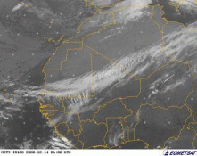
Source: earthobservatory.nasa.gov
In the Atlantic ocean, these tropical disturbances are known as the Easterly Wave. A low pressure area develops over Africa and flows westward out over the Atlantic. Here is where they gather strength from the warm water below to form the thunderstorms that could produce a Hurricane. Click the image at left to view the Easterly Wave migrating off the African coast.
As more air condenses and latent heat released, thunderstorms grow. The latent heat generated inside these thunderstorms create a pressure gradient between the storm and the surrounding atmosphere. Since warmer air is less dense than cooler air, the pressure of the column of air under the storm decreases. This decrease in pressure forces air surrounding the storm to flow towards the center of lower pressure. Air flowing from all directions converge and ultimately are forced upward into the storm. The converging air brings even more warm, moist air into the storm, releasing more heat as it condenses. As this cycle continues, thunderstorms grow and strengthen.
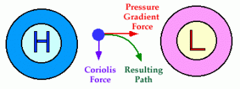
Coriolis Force
Source: www.cleonis.nl
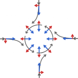
As the thunderstorms grow and create an area of low pressure, a pressure gradient develops. Surrounding air (in higher pressure) will begin to flow towards the low pressure center. However, since the earth is rotating, the wind will appear to curve to the right as observed at the ground in the northern hemisphere (In the southern hemisphere, the wind will curve to the left.). This is due to an apparent force known as the Coriolis force.
So, why does the wind around a low pressure center flow counter-clockwise if the Coriolis force deflects wind to the right? First, keep in mind that this is based on the northern hemisphere perspective. As surface winds from all directions begin to flow toward the low pressure center and are deflected to the right, the resulting effect forces a counter-clockwise wind direction. The diagram to the right is a good visual representation of what's going on. The blue arrows indicate the pressure gradient as winds flow from higher pressure to lower pressure. The red arrows represent the Coriolis force. The resultant wind direction is perpendicular to the pressure gradient and is known as the Geostrophic wind. This wind flows around the lower pressure center and causes the organized cluster of thunderstorms to rotate counter-clockwise.
So, why does the wind around a low pressure center flow counter-clockwise if the Coriolis force deflects wind to the right? First, keep in mind that this is based on the northern hemisphere perspective. As surface winds from all directions begin to flow toward the low pressure center and are deflected to the right, the resulting effect forces a counter-clockwise wind direction. The diagram to the right is a good visual representation of what's going on. The blue arrows indicate the pressure gradient as winds flow from higher pressure to lower pressure. The red arrows represent the Coriolis force. The resultant wind direction is perpendicular to the pressure gradient and is known as the Geostrophic wind. This wind flows around the lower pressure center and causes the organized cluster of thunderstorms to rotate counter-clockwise.
For more information on hurricane rotation, click on the images below.
 Source: ww2010.atmos.uiuc.edu |
 Source: ww2010.atmos.uiuc.edu |
Weak Vertical Wind Shear
With altitude, pressure can vary. And within each pressure level, the geostrophic wind can vary. The difference in geostrophic wind between parallel pressure levels is known as the thermal wind. The thermal wind is also known as wind sheer.
To allow these thunderstorms to continue to grow, wind shear in higher altitudes needs to be at a minimum. Otherwise, high wind speeds aloft can inhibit convection and reduce the strength of the thunderstorm. Also, high wind shear can break up an already developed hurricane by removing the heat it's generating. Typically, low wind shear between the surface and the upper troposphere is required for the storms to form and intensify.
To allow these thunderstorms to continue to grow, wind shear in higher altitudes needs to be at a minimum. Otherwise, high wind speeds aloft can inhibit convection and reduce the strength of the thunderstorm. Also, high wind shear can break up an already developed hurricane by removing the heat it's generating. Typically, low wind shear between the surface and the upper troposphere is required for the storms to form and intensify.
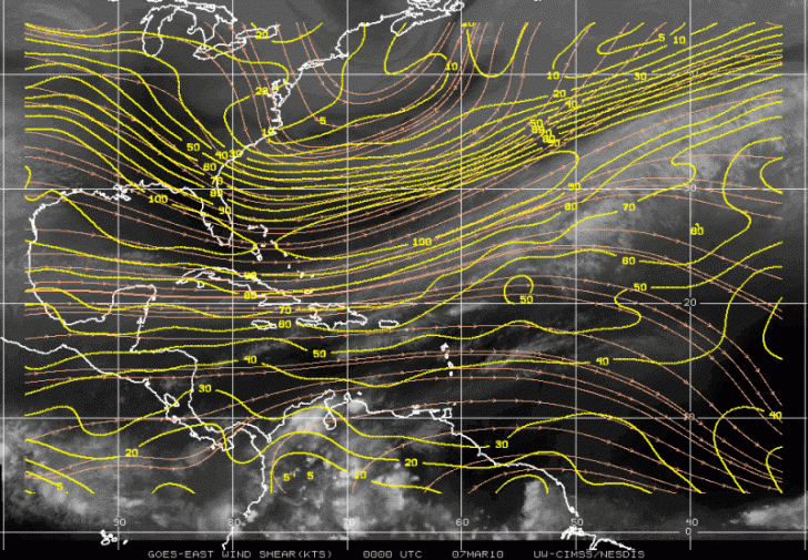
Source: http://cimss.ssec.wisc.edu
The University of Wisconsin website displays real-time wind shear measurements over the western Atlantic. It also illustrates upper and lower level winds and convergence/divergence wind measurements.
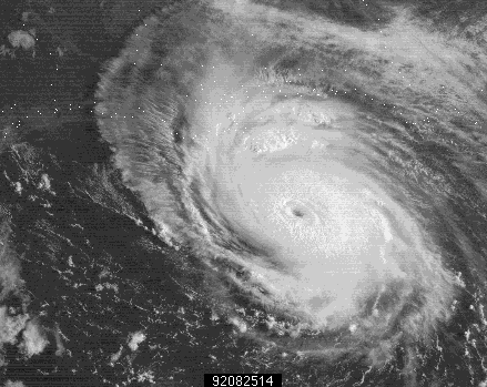
A Hurricane Is Born
Source: ww2010.atmos.uiuc.edu
As the rotating thunderstorms move across the ocean, they gain more strength as more warm, moist air is carried into the storm. Pressure in the storm continues to drop causing a larger pressure gradient. Winds head into the storm with increasing velocity. As winds increase, the storm's rotation accelerates and the structure of the storm begins to organize. The tropical cyclone is considered a Hurricane once there are sustained winds of 74 mph (64 knots).
Click on the image to watch a short video of a hurricane spinning in the Gulf of Mexico.
Click on the image to watch a short video of a hurricane spinning in the Gulf of Mexico.